Few islands evoke such mixed reactions as South Uist. Many who visit this outpost in Scotland’s Outer Hebrides are seduced by the serenity of the landscape and the warmth of its people. After a period serving as the first Catholic head teacher to be posted to the island since the Reformation, FG Rea wrote of the community hewas leaving: “Simple folk, brave, enduring, generous and warm hearted, true and faithful friends.”
Not everyone agrees. The clairvoyant Ada Goodrich Freer, who visited in the 1890s when Reawas on the island, inclined to a harsher view: “The most forsaken spot on God’s earth,” she wrote of the island. Freer elaborated: “The very existence ofthe island of South Uist is itself a tragedy which shames our civilization.”
The lie of the land
South Uist is an island of extraordinary contrasts. It runs for about 40 kilometres from north to south and is rarely more than a dozen kilometres in width. Antique maps of the Outer Hebrides sometimes refer to the entire archipelago, from the Point of Ness in the north right down to Barra Head in the south, as ‘The Long Isle’ (An t-Eilean Fada in Gaelic). South Uist can take much of the blame for that. It’s long, straggly and — in theview of some travellers — a water-strewn bog with little to detain those in a rush. Some observe that South Uist gets in the way as visitors travel from South Harris, with its remarkable beaches, down to beautiful Barra. Whereas Barra and South Harris are pleasingly round in shape — the archetypal island of the imagination — South Uist is elongate, a wild straggle of land and water that cartographers have painstakingly endeavoured to map accurately. It’s not easy!
There is only one main road, and it runsthe entire length of the island. Since 1942, SouthUist has been linked to its northernneighbourBenbecula by a road which bridges the shallow tidal inlet betweenthe two islands. That link iscalled South Ford Causeway.
It was not till 60 years later that the causeway across to Eriskay, the next island south of South Uist, was opened. With the opening in 2003 of the Sound of Barra car ferry, linking Eriskay with Barra, it became all too tempting for motorists to just dash through South Uist, without so much as even setting foot on the island.The drive from the end of South Ford Causeway down to the start of the elegant causeway and bridge over to Eriskay takes barely an hour. And, for almost the entire length of South Uist, that road traverses a melancholy strip of blacklands — peaty bog, riddled with freshwater lochs where, before the coming of proper roads, the hapless traveller would, in the absence of a competent local guide, struggle to make progress.

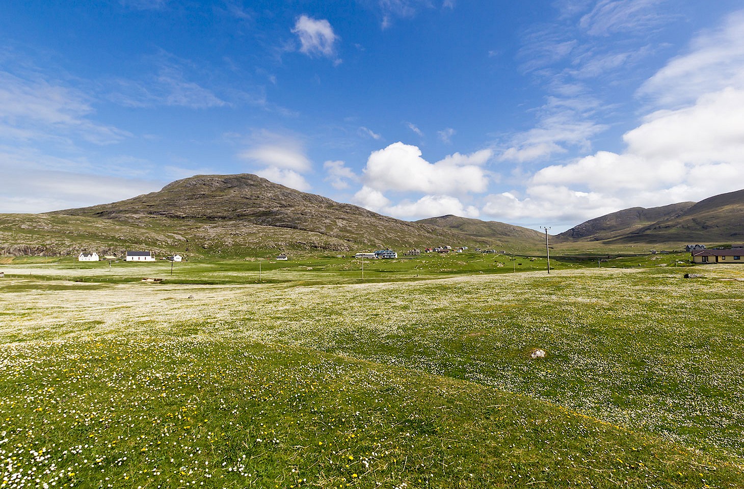
Looking over the peaty blacklands to the hills which line the eastern side of South Uist (photo © hidden europe).
But there’s more to Uist than the blacklands. Visitors who take time to explore South Uist discover three very different landscape units which run for most of the length of the island. Along the island’s eastern side there are wild hills, rising totwo prominent summits in Hecla and Beinn Mhor.Their rock-strewn slopes plunge down towards the sea. The west coast couldn’t be more different with its white shell sandy beaches, fringed by dunes andbacked by flower-filled sandy grassland (known as machair). Down the middle of the island, in a strip between the machair and the hills, are the blacklands.
Three great inlets penetrate inland on the wild east coast: Loch Skipport to the north, Loch Aineort in the centre of the island’s east side, and Loch Baghasdail towards the southern endof South Uist. There is real drama entering Loch Aineort from the Minch — that’s the sea area which separates the Outer Hebrides from the islands closer to the Scottish mainland. With the hills rising up on all sides, Loch Aineort is a real Hebridean fjord one which, with its strong tidal flows, overfalls, eddies and tortuous channel is a challenge for even the most experienced of mariners.
That east side, bar for the area around the substantial harbour at Lochboisdale where the ferries from the mainland arriveon South Uist, is sparsely populated. Andso, too, is the west coast. For the sandy machair grasslandsand the beach are ill suited to habitation. That leaves only the blacklands, that long peaty strip down themiddle of the island, for human settlement,where the most favoured locations are just at the points where the blacklands nudge up against the machair — it is at this interface that the most fertile land of South Uist is to be found.
Everywhere, whether on the dunes,on the shards of dry land which tussle with the watery bogs in the blacklands, or on the mountains that line the east side of the island,there is the relentless west wind which makes the grass bend before it.
An elderly woman tends a grave at Hallan Cemetery, a burial ground with an enviable location on the sandy machair, boasting fine views out to the Atlantic. “It’s a battle here to keep the place tidy,” she says.“But it’s a fine spot for a burial,” she adds, noting that it’s only in death that the residents of Uist enjoy such privileged surroundings. Here in the west of the island, there are the great dunescapes,the corncrake and the lapwings. “The east has the mountains with the sea eagles; and that leaves the middle for the humans who are still alive,” says the woman. Death in South Uist means moving west onto drier terrain.
The middle is irredeemably damp. “It helps if you have webbed feet,” adds the grave tender, echoing the comment of John MacCulloch who, when he was President of the Geological Society of London in 1816, visited the Outer Hebrides and concluded that South Uist was “a land fit only for wild ducks.”
Most visitors to South Uist who take time to stop on the island end up in the bar of the Borrodale Hotel at Dalabrog, right on the main roadabout two thirds of the way down the island. They often ask how many people reside on the island. It’s a question which always elicits the same retort from the bar staff. They’ll ponder, look the visitor straight in the face, and then slowly ask: “Now, will that be just the living or shall I also include the dead?”
Margaret Fay Shaw
For life and death, the past and the present, are deeply blurred in South Uist. It’s an island which lives on its history, but can never quite escape it.The American-born photographer Margaret Fay Shaw who, with her husband John Lorne Campbell, later became a great champion of the Gaelic cultural heritage of the Hebridean islands, quickly spotted the special appeal of South Uist when she arrived on the island as a young woman in 1928.
The comings and goings at the port of Lochboisdale offered, Margaret realised, no great rewards for those keen to understand the nuances of traditional Uist life — although she may have taken a more positive view of Lochboisdale after she met her future husband at the quayside hotel there in 1934.
Reflecting on her early weeks in Lochboisdale, Margaret wrote “There was not the opportunity for a beginner to speak Gaelic nor to hear the old traditional songs and observe crafting life.” So,after a chance encounter with Peigi and Màiri MacRae, she moved to live with the two sisters in their tiny Hebridean blackhouse at Gleann Dail (curiously one of the few Uist toponyms where the English rendering, Glendale, has as much currency as the Gaelic name).
North Glendale, where the three women lived, is still a rare sheltered part of the island where there is often respite from the west wind. Margaret Fay Shaw developed an extraordinary affinity withthe families who inhabited the dozen or so crofts around the glen, keeping careful records of the language, the words and melodies of folksongs and the day-to-day rituals of South Uist life. And in time, she moved from the role of mere scribe to becoming a champion of what was already a way of life threatened by modernity. As one Glendale bard put it: “There was a dying ember, she blew on it and brought it to life again.”
Even in the early 1930s, when Margaret was fully a part of Glendale life, the dominance of the Gaelic language was being threatened across South Uist. And the old blackhouses, the traditional Hebridean taighean dubha, were being forsaken for more modern dwellings. But it was in just such a blackhouse, surrounded by ragwort and occasionally plagued by brown rats, that Margaret lived with the MacRaes. Twenty years later she was to mourn the passing of the old ways. Writing in 1955,in the introduction to her Folksongs and Folklore ofSouth Uist, Margaret recalled that the glen, hitherto only accessible by boat from Lochboisdale, now had road access, the school had closed and “the thatched houses, so warm and comfortable in winter storms, have been condemned to extinction by an unimaginative authority which prefers two-storey wooden Swedish prefabricated houses.”
Margaret Fay Shaw died in 2004, having spent the last 65 years of her life on the island of Canna, which she and John Lorne Campbell purchased in 1938. It became the home base for a husband-and-wife team who over several decades documented and championed the traditional cultures of the island Gaels. Margaret is buried next to the MacRae sisters in Hallan Cemetery on South Uist.
Today, visitors to Glendale arrive easily by car, following a side lane which tracks east from the island’s spinal road. Though fewever leave the main road, there are rewards for those who do. For, on a good day, there are gorgeous views north from Glendale over a great web of low, rocky, tidal islands to the ferry port of Lochboisdale in the distance. The lazy beds (what an absurd misnomer for a form of agriculture which demanded such labour) around Glendale are long abandoned, but the place is spick and span, with a neat loch-side memorial commemorating the bards of the glen. This is a place to pause and listen to voices from beyond the grave, the voices of the women and men of Glendale who shared their lullabies and laments, their songs of love and war, the melodies of waulking, milking and spinning, and indeed their whole lives with Margaret Fay Shaw, the inquisitive incomer whom they accepted as one of their own.
For life and death, the past and the present, are deeply blurred in South Uist. It's an island which lives on its history, but can never quite escape it.
It is the soundscape of the Gaels which is like a ligature between the living and dead.In South Uist, the wind, the music and thesoft Gaelic prayers of Catholic Mass all help define that soundscape. The social scope of the cèilidh — the traditional gathering of neighbours and friends — may have been trimmed, but there is still a distinctive web of familial and wider ties that is so much a feature of the southern islands inthe Outer Hebrides. Nowhere is this more evident than in the stories told about the ruined crofts and abandoned homesteads which dot the blacklands of South Uist. Gaunt, grey gables prod the sky like monstrous gravestones. Abandoned agricultural equipment rusts next to decaying farms, attesting to former Herculean efforts to wrest something from this unforgiving land. So prevalent are these symbols of loss and longing that the naive visitor exploring the remoter corners of South Uist mightfeel she had somehow stumbled into a dominion of the dead.
War and peace
Father Michael MacDonald has just presided over a funeral at his parish church at Ardkenneth towards the northern end of South Uist. Thehymns at the Requiem Mass were all in Gaelic.The church itself is elegant in its simplicity, along, white rectangular structure under a slate roof, its harled white walls perforated by three striking depressed-arch windows. Father Michaelis especially proud of the interior decoration ofhis church, which he says showcases “the best of local art”. The presidential chair, the pulpit, thenew altar with its striking coloured panels and theicons in the church are all by Hebridean artists.
Outside his church, Father Michael reflects on life and death in the scattered community which he serves. “It’s never just one funeral,” he says. “They come in twos and threes, sometimes more.”
The Catholic priest is acutely aware of the special status that faith has in South Uist. In the1880s, it was the intervention of the Church which so powerfully swayed the Crofters’ Commission and led to the Crofters Act of 1886. Described by John Lorne Campbell as “the Magna Carta of the Highlands and Islands”, the Act fundamentally reshaped the relationship between landowners and tenants, affording to the latter a new level of security. That move alone emboldened Catholics to enter wider civic debates, no longer ever-fearful that an intervention in island affairs may lead to them being dispossessed. Catholics suddenly had a voice on schoolboards, and used it to good effect, making it possible for Catholic teachers like FG Rea — mentioned at the very start of this article — to secure positions on South Uist.
“Now, take a look at that,” says Father Michael, pointing to a weathered sandstone statue on the plinth on the north side of his church. It’s a Madonna and Child, striking in its simplicity although decades of lichen detract from the dignity of the piece.
“Our Lady of the Isles. It’s the maquette for the famous statue on the side of Rueval,” he explains. Amaquette is a sculptor’s small-scale trial essay for a grander piece. And there’s no grander sculpture in South Uist than Hew Lorimer’s oddly attenuated statue which stands on a hillside overlooking the spinal road half way down the island.
“This maquette dates from 1957,” explains Father Michael. “It was a difficult time for the Catholics of South Uist,” he adds. “There was a lot of fuss over the plans for a missile range on the island. And it was one of my predecessors here, Canon John Morrison, who led the local community in protests. They called him Father Rocket.”
John Morrison’s energetic intervention in the debate over the plans for a huge military base, extending from Solas in North Uist through Benbecula to Bòrnais in South Uist secured international media attention, and the Ardkenneth priest is widely credited for the eventual decision to scale back the plans.
Today the missile range occupies a good stripof machair at the north-west of the island, but there are military facilities elsewhere— notably the tracking station on Rueval where Hew Lorimer’s Our Lady of the Isles acts as a religious counter point to a motif of war.
Stand by that great sculpture on windtorn Rueval, or indeed by the maquette of Our Lady of the Isles at Ardkenneth, and one can sense the utter isolation of this island on Europe’s wild Atlantic fringe. Even in a fierce gale, there is a stillness and a solitude which is everywhere reflected inthe photography of Margaret Fay Shaw and the many other writers and photographers who have been drawn to South Uist — among them the American Communist photographer Paul Strand whose 1950s images of South Uist are among the most evocative of any Hebridean photography. They capture an inspiring community — but one living in the shadow of Cold War politics.
The location of Hallan Cemetery on South Uist in Scotland's Outer Hebrides.